Twenty thousand years ago, the Ice Age in the northern hemisphere was at its maximum, and sea level fell to 130 metres lower than today. New Guinea merged with Australia and Tasmania, forming the greater continent known to archaeologists as Sahul.
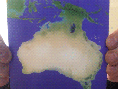
Lenticular cards show different images depending on the direction from which they’re viewed. This card transitions through a series of geographical reconstructions to contrast the ancient ‘Sahul’ continent with Australia as it exists today. The cards offer a convenient way to illustrate discussions of Australia’s archaeological past, perhaps when consulting with traditional owners and other communities in the field.
These images were generated from topographic data of land height and bathymetric surveys of the sea floor, along with a simple model of the drier climate of ancient Australia. They appear when the Time-machine.Earth timeline is zoomed out to cover 60,000 years, along with the AustArch dataset of archaeological dates, and selected megafauna fossils from the FosSahul dataset.
A new version of the SahulTime visualisation (originally launched in 2007), is now available, offering landscape visualisations of various sites around Australia – a capability that will hopefully be implemented into a future version of Temporal Earth.